This is the blog I knew I would have to write eventually, and I suspect some of you will welcome it.
Our supernaturally dry, warm period is going to end on Friday. We are close enough now and the agreement of the models are sufficient to suggest substantial confidence in this forecast (yes, there is a small probability it could be wrong).
Much of the region has had probably the finest late summer/early fall weather of the past half century, with the only downside being the fires, smoke, and our water bills.
Right now the atmosphere is locked in a very stable blocking pattern, one called a Rex Block (after Mr. Rex, not some king, although many of us might consider this royal weather). In a Rex Block there is a ridge to the north and a closed low to the south in the upper level maps. Here is the forecast map aloft (500 hPa) for 2 PM today to illustrate. With a ridge over us, there is naturally a trough over the eastern U.S., where some folks are getting record cold and snow.
To illustrate what will happen this week, consider the sequence from the latest National Weather Service GFS model prediction (the European Center forecasts are very similar).
First, Monday. Generally similar pattern and our warmth and lack of rain will continue.
Thursday at 5 PM. The block is weakening and you see flow coming in on the western boundary. (this is when the Jaws music of impending doom should be played). Still dry over us at this time, but with the closed low moving into southern CA, residents of LA will be cloudy and moistened a bit. They can always retreat to their hot tubs.
On Friday afternoon, the ridge is movingeastward, we are getting moderate westerly flow, and are weather is deteriorating, with clouds and perhaps some light rain on the coast.
And here is Sunday afternoon. A strong trough moving just to our north and I suspect some light rain spreading to the NW interior. No big storm, but coastal Vancouver Island could be quite wet.
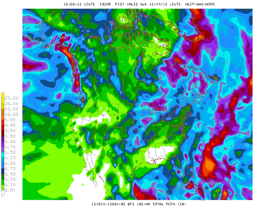
Let me show you some fun graphics, never before shown on this blog...the cumulative rainfall from the NWS GFS model. Here is the total rainfall falling between 5 PM this morning (Saturday) and Thursday at 11 PM. Almost everyone get precipitation except us! Even southern CA gets wet.
And here is the same cumulative rainfall, but ending on Sunday at 5 AM. Finally, some light rain spreads over the region. Sorry.
Basically, our protective block is gone by next weekend and we will be vulnerable to passing storms in a progressive pattern. Will the ridge come back? Some models are hinting at it, so stay tuned.
Home »
» Summer is Over on Friday


Post a Comment