A weak front is now bringing clouds, rain, and cooler temperatures north of Seattle, while to the south it is dry and much warmer. Head to Portland and you can enjoy a warm sunny day. Here is the latest weather radar image:
 The northern rain is apparent. You don't see much rain over the mountains...but don't believe it. The Camano Island radar is substantially blocked by the lower foothills and we can't see what is happening at higher elevations very well. You can also see a bit of the Olympic Mountain rainshadowing.
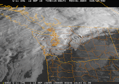
Here is the new visible satellite picture. Clear in Portland and over SE Washington. And if you look closely you can see wave clouds east of the Cascade crest.

Eastern Washington needs all the sun it can get so the grapes can ripen. With a cool spring and late summer, the maturation process is well behind according to some reports:
http://www.wawinereport.com/2010/09/perfect-storm-does-washingtons-2010.html
Interestingly, the author describes 2010 as a meteorological "perfect storm" for wine, with periods of above normal and below normal temperatures and excessive precipitation that leads to mold and mildew. The quality of the NW wine crop is not simply of academic interest for many of us!
Here is are the temperatures at Pasco the last two weeks. Most days are are not getting to normal and nighttime temps are dropping into the low 40s. And the downward trend is very clear.
 After our front moves through today, there should be an improving trend for a few days. But let me be honest: current forecast models indicate a very wet weekend coming up. That could change of course as we get closer, but this solution has been quite stable. If still there on Wednesday's runs, it will probably be a reality.


Post a Comment