During the next few days a disturbance off of Asia (Typhoon Chaba) will move northward, turn into a midlatitude cyclone and amplify into an extraordinarily deep low pressure center (see graphic). We are talking about 939 mb! (compare that to the 955 mb over the Midwest that everyone was excited about two days ago). There are so many isobars near that low the graphic is turning black!
 The monster storm, huge in scale and possessing hurricane force winds, will produce giant waves--greater than 50 ft high. I could fill an entire blog about this storm...but there is a more acute worry here at home.
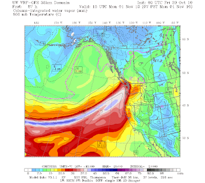
As the low pushes into the Gulf of Alaska it will result in the establishment of a very strong, moist current heading right for our region. You know the names---atmospheric river is the generic term and our version is often called a pineapple express. The next graphic presents the early stages of this feature (Monday AM)....the total amount of water vapor in a vertical column is being shown:

You can see the current of moist air heading right for us.
Here is the 24-h rainfall prediction ending at 5 AM Tuesday. Red indicates 5-10 inches of precipitation over the Olympics, north Cascades, and mountains of southern BC. Precip decreases rapidly to the south.

A looks at a closer view for the same period below. A profound rainshadow will also exist NE of the Olympics. I am sure the National Weather Service will be putting out some statements on potential flooding of rivers coming off the Olympics and N. Cascades. At this point it does not look like a situation that would produce urban flooding over the Puget Sound population areas.
 The plume of atmospheric river air over us on Monday and Tuesday will feel warm, moist....almost tropical after the cold weather. Freezing levels will rise to 8-10,0000 ft and a lot of the new snow will melt (sorry snow lovers).
I should be clear that there is often a lot of uncertainty with these cases of tropical storms converting into midlatitude systems. But the computer models have really locked on to this solution and we are close enough now in time that I am believing it. Lets face it, it is really extraordinary we can do this at all.


Post a Comment