This week we have experienced several weather records. On Monday, Seattle had the wettest November 1 since record keeping began (1.45 inches) and on Wednesday it had the warmest November 3 on record and tied the ALL TIME daily record for any day in November. A reporter called up this week asking whether "all this weird record breaking" is a sign of something...like global warming.
The truth is that there are records and then there are records.
Breaking daily records happens all the time.
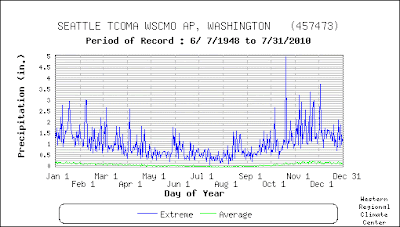
Heavy rain is associated with storms and for the relatively short records available for major stations (roughly 60 years at Sea Tac) is not hard for a few days to be missed. Then if you get a decent storm on that day...you break the all-time daily record! Really not the remarkable.
Let me demonstrate this to you. Here is a plot of the daily record precipitation at Sea Tac Airport (blue line) and the daily average (green). You notice how spikey and irregular the plot of record precipitation is. In November some days have daily records of 3-4 inches, while some are substantially less than an inch. Breaking the record on one of the low days is no big deal...any moderate storm could do it. Is that a record to be touted in the press? I don't think so.

On the other hand a record like Wednesday's high temperature is more significant. We tied the all time daily record for the month--of ANY day. But perhaps not as significant as one might think since the temperatures really plummet after the first week of the month. So most of the month really doesn't count.
Want to see that? Below is a plot of the daily records for November, and the temps so far from the National Weather Service web site. The first four days have some fairly toasty records..with a peak of 74F on November 4 (occurred in 1949) and now November 3 as well. But from the fifth on there is not a single day the temperatures got in the 70s and the records rapidly drop into the lower 60s. Bottom line: we have had a number of years where the first week of November has had some pleasantly warm temperatures, but then it ends decisively after November 5. The record mimima are really uneven after November 10th.
 Finally, it is useful to keep in mind that the temperatures are rarely normal. Normals usually represent the average of above normal and below normal temperatures. Want to see proof? Here is a plot of the actual temperatures the last two weeks (dark red line) and the average highs and lows. The high temperatures are rarely normal but are found below (early part of the period) and above (later part) of "normal." The two week period probably has an average maximum close to normal. You see how much that tells you.
Kind of like kids in a some high schools...very few are average! (sorry, couldn't help myself)


Post a Comment