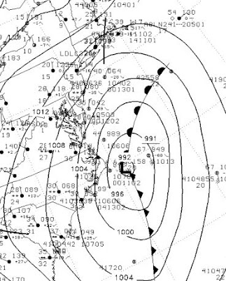
The greater winter storms of the U.S. East Coast are called Nor'easters because of two reasons: first, they move up the coast to the northeast, and secondly, because as the low moves up the coast the winds hitting the coastal zone is FROM the northeast. Nor'easters bring strong winds and heavy precipitation to the coastal zone and during winter can be associated with heavy snow and blizzard conditions. The approach of the current storm resulted in pre-emptive cancellations of hundreds of flights yesterday and particularly today.

Above is a recent surface chart for the East Coast. The low center is off of Cape Hatteras and the precipitation shield has spread from North Carolina into New England. See how useful a coastal radar is, and how outrageous it has been that we haven't had one!

And here is the infrared satellite picture. You can see the hook shape associated with the circulation of the storm.

Computer models are suggesting the storm will strengthen and move northeast...here is the predicted pressure and precipitation pattern later tomorrow AM. Lots of isobars, which mean large pressure differences and wind. The winds rotate counterclockwise around the low and are roughly parallel to the lines...so very strong NE winds will hit the NY metro area and N. England. Cold air is pushing south in this flow and heavy snow and strong winds will be experienced. Often the snow is enhanced in narrow bands, the position and intensity of which are very hard to predict.
 LaGuardia Airport is now stopping planes from taking off and many flights in regional airports have been closed. Winds are now gusting to 20-30 mph at many locations and it will get much worse. This is fairly early for such a major coastal snowstorm, and the season extends in March.
Northeasters, like our coastal storms (which also move to the NE), are extratropical cyclones, dependent on horizontal temperature gradients for their energy. Northeasters can derive energy from the huge temperature differences between the cold air of the interior and the warm Gulf Stream offshore. The movie, the Perfect Storm, was about a Nor'Easter, back around Halloween of 1991. If you want a laugh check out the section of that movie with the meteorologist looking at the satellite picture, shaking in expectation--"oh my God!, you can be a meteorologist for decades and now see something like this" or something like that. And then the actor points to the wrong thing on the wrong satellite picture.... Want to see a bit of this? Go to around 54 seconds and play:
http://www.youtube.com/watch?v=gVwuy-4TzU8
(sorry...viewing the wacky and wrong stuff about weathermen in movies is an evil pleasure for me)
Finally, it DOES look we will cool down midweek and there is a chance of some lowland snow showers. Right now the set-up is not ideal for anything major....so don't get too excited. Lots of snow in the mountains though...


Post a Comment