So midway, how has the winter panned out? Has the La Nina connection worked out the way we expected so far? The media has been talking about the "wacky" weather and California is experiencing flooding and heavy rains. Lets stand back for a second and review.
Here is the departure of precipitation from normal over the last sixty days. Green and blues are above normal.
 Bottom line: most of the West Coast has been wetter than normal by 2-8 inches, with the most anomalous wetness over the Sierras of California. In fact, Los Angeles is on track to have their wettest December on record. Is this pattern consistent with La Nina?...not exactly. During La Nina years the NW is usually wetter than normal and central CA is drier than normal. So, the California wetness was not expected. But keep in mind that the La Nina/El Nino correlation to West Coast weather is really only about probabilities....the wet north, dry south pattern is more probable....but other things CAN happen.
Here is the same map for departure of average temperature from normal for the same 60-day period. Temperatures generally near normal. This is what we expect for the first part of La Nina winter...the colder than normal temps generally occur after the New Year. But we have had some short periods of warmer and cooler than normal temperatures.

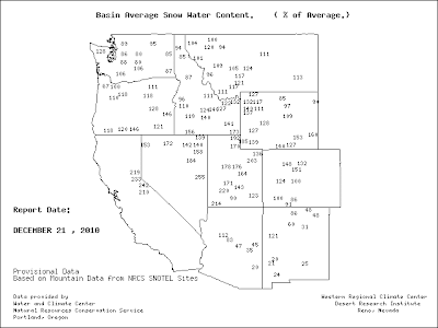
What about snowpack? Over Washington we are at or a bit BELOW normal right now (see map), and as you go south the snowpack is decidedly above normal..roughly 120% in Oregon and over 200% in the Sierras. California needs all the water it can get, those poor devils! Based on La Nina conditions we would expect the Northwest snowpack to zoom well above normal during the next two months....but again, this is a statistical correlation, not an exact prediction.

Next, here is a plot of temperature at Seattle Tacoma Airport since Nov 1, including the average high and low temperatures. Well above normal in early November and below normal for that week in November. Since then we have been very near normal most of the time, perhaps a bit above normal. Average the whole winter, nothing unusual! You can see how deceiving long-period averages are....we had record highs for a short while and record lows at other times and the seasonal average will be near normal.

And here is the cumulative precipitation at Sea Tac for the same period. Roughly two inches above normal. Long periods of light precipitation, with a big hit earlier in December when we had the flooding.

Has this early winter been wacky and unusual? Not particularly. Pretty much every year there are storms and floods and daily records. Sign of global warming? No reason to think so.
Finally, thanks for all your positive statements from my last blog. Most of you are wonderful and respectful, but there is a very small minority whose comments, both on this blog and in separate emails, range from the bizarre to the mildly threatening.


Post a Comment