So how strong did the winds get? Here is a list of a few locations. One unofficial spotter at Three Tree Point near the Sound reported a 63 mph gust. For many locations, the winds yesterday were the strongest over the past year.
Spd(mph) Time(PST) Location
----------------------------
60 ~11:30 Alki Point Light
56 11:32 Bellingham Airport
54 11:31 Whidbey Island NAS
58 9:21 Smith Island
56 11:46 Paine Field
54 11:45 Edmonds Marina
58 11:22 West Point Light
53 11:50 Evergreen Pt Bridge
41 11:28 Boeing Field
53 11:16 SeaTac Airport
43 11:50 Renton Airport
and..as noted in a comment below, 122 mph at Camp Muir on Mt. Rainier!
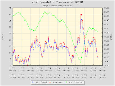
Here is a plot of the hourly winds at Seattle's West Point. You will see how quickly the winds rose, peaked, and dropped and the very intense pressure trough (large pressure drop before the highest wind, followed by an intense pressure rise). Green is pressure, blue sustained winds and red are gusts.
Imagine taking a ferry ride across the Sound? Here are the winds from the Edmonds/Kingston ferry. SUSTAINED winds of up to 47 knots (54 mph)! The would been an exciting trip.
This wind event was associated with a strong front, one that was unimpressive in terms of precipitation, but one with a very strong pressure trough and wind shift. It is also an event that new coastal radar provided a lot of hints of possible strong winds.
Here is a forecast from the UW WRF model (initialized at 4 PM on Saturday) for 7 AM on Sunday. Very sharp front. Large north-south pressure difference and strong southerly winds in front of it. Very sharp wind shift to westerlies behind it.
In addition, coast observations, such as at Destruction Island, indicated an unusually intense frontal passage, as shown below.
Anyway, a good example of what a strong frontal passage can do and the strengths and limits of our technology. An example of why we need more effective nowcasting--short-term diagnosis and forecasting. And one more thing...there is a lot of action predicted for this week...so keep tuned.


Post a Comment