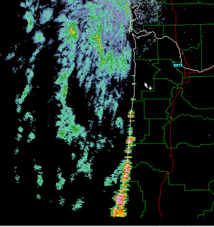
First, let me show you what I am talking about...here are two radar images for 8:38 PM on Friday and 6:49 PM on Tuesday. Lots of apparent rain offshore, but very little over land...very strange!
And lets compare these radar images to the visible satellite imagery at nearly the same time:
All that rain is not coming from clouds! So if this is not some sort of alien intervention, there must be another explanation! And there is.
Last weekend and early this week the land surface temperatures have been relatively warm, and most importantly the lower atmospheric temperatures have been warm. But the surface temperatures of the eastern Pacific have remained quite cool--roughly 50F. With warm temperatures aloft and cool sea surface temperatures, a low-level inversion (temperature warming with height) formed over the ocean. We don't have a balloon-launched radiosonde over the ocean, but I can show you the simulated conditions from the UW WRF modeling system there. The red line is temperature and you can see a shallow, cool marine layer surmounted by an inversion.
So why is this important? It turns out that such low-level inversions can bend the radar beam downward towards the surface...we call this superrefraction (see figure). Radar beams are generally bent a bit (refracted) by the normal atmosphere, but inversions greatly enhance this refraction, enough so that the bean is bent back to the earth. In fact, under inversion conditions (like this weekend), the refraction is so complete the radar beam is trapped near the surface (this is called ducting).
It appears that the radar beam from the Langley Hill radar was not viewing precipitation in the air at all, but rather intersecting the sea surface and reflecting back! The ducting allowed the radar beam to skim the surface for hundreds of kilometers. To see this, look at this radar image I got from my colleagues in the National Weather Service...the radar beam was hitting and returning from coastal terrain way down the Oregon coast.
This problem was only apparent for the lower radar scans (.2 and .5 degrees above horizontal). For the higher scans..1.5, 2.5 and higher...there was nothing out there--consistent with the superrefraction mechanism. Today I was on a conference call with NWS radar experts in Norman, Oklahoma. They told us they had never seen such a profound, sustained superrefraction/ducting event...one for the record books.
The thing is, this is not the end of this issue. When we get warm again, the mysterious ocean rain will be back. The TV weathercaster folks will have to keep this in mind when they show the coastal radar imagery.
The event will be centered south of us, but the event will occur around 6 PM on Sunday. Unfortunately, it looks like most of our region will be clouded over at that time. Sorry. Will update on Sunday AM.


Post a Comment