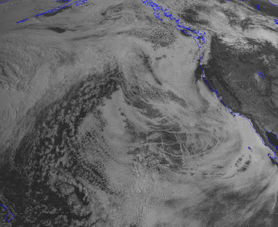
Sometimes during springtime one looks at the visible satellite imagery over the eastern Pacific and can't help but be impressed that nearly the entire ocean is covered by low clouds. This morning provides a prime example:
Pretty amazing. You have to feel sorry for those poor mariners crossing the ocean with day and day of low clouds (mainly stratocumulus). Even central and southern California coastal residents are in the murk and you can see the low clouds spreading to the crest of the Oregon and Washington Cascades. Folks, this is what June gloom looks like from space.
You see the checkerboard pattern over the ocean? Those are ship tracks....the result of the effluent from fossil fuel burning ships. The particles from combustion result in more condensation nuclei and more water droplets. More droplets results in more of the sun's rays being reflected back to space. Here is a close-up view. You can see why the U.S. Navy likes nuclear ships...no ship tracks!
To illustrate the murk at ground level, here are the latest webcams at Cannon Beach Oregon:
and at Del Mar near San Diego.
Kind of makes a Northwestener feel better...we have have company.
The ironic thing about this extensive shield of low clouds is that it is the result of HIGH PRESSURE.
Don't believe me? Well, here is the proof...the 6-h forecast for sea level pressure over the eastern Pacific. A huge high pressure area dominating the eastern Pacific, while low pressure is found over the southwest U.S.. Between the two there is a large difference in pressure near the Oregon/CA border...which produces very strong winds there (described in a previous blog).
High pressure produces sinking air and sinking causes warming. The sinking decreases as the air approaches the surface. So with strong warming aloft and cool water near the surface we end up with an inversion (warming with height) in the lower atmosphere. So we have a veneer of cool, moist air (with lots of low clouds) near the surface and dry warm air aloft. Here is the latest sounding from Quillayute on the Washington coast (red is temperature, blue is dewpoint)... this structure is really obvious.
The vertical axis is pressure. 850 hPa is roughly 5000 ft. Where the temperature and dewpoint are on top of each other we have a saturated (cloud-full) environment. Here is a similar figure for San Diego (no color coding of lines). Same structure.
So the secret of getting away from the low clouds is either to go above roughly 3-5 thousand feet (good if you own a helicopter or can hike up a local peak) or cross the Cascades. Sorry.
Home »
» Ocean Full of Clouds


Post a Comment