To warm up, here are a few pictures I found at the KING-5 weather site (taken today by donmonroe) near the Skagit Valley.
Here is a great video of the convection developing yesterday: click here.
Such active convection was not isolated in western Washington, but extended over and east of the Cascades. You can see the story in the visible satellite imagery. At 9:30 AM (first image), there was clouds and a few light showers around.
By noon as the earth warmed, convective clouds (white speckle look) had developed over a lot of the land...but not so much over the cool water.
By 3 PM, the shower clouds had become larger and more intense, particularly to the south of the Sound and over the eastern slopes of the Cascades and over NE WA.
And, of course, you could see the showers in the radar...here is an image around 5 PM...notice how the showers have moved away from the Sound and were particularly intense near and SE of Olympia.
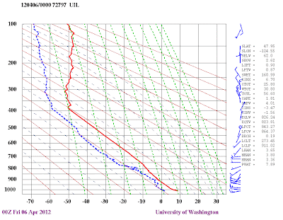
Why such vigorous convective showers today? The reason: there was a huge change in temperature with height....also known as the vertical lapse rate. Today at 5 PM, at around 18,000 ft (500 hPa pressure) the temperatures were around -36C (-35F), while near sea level the temperatures were around 50F. That is a very large difference in temperature. Such large vertical temperature changes result in the development of vertical instability, or convection, just as you see in your hot cereal pot when you heat it from below. Meteorologists can appraise the potential for convection by plotting temperature and dewpoint on a sounding chart. Here is one at 5 PM for Quillayute on the coast (red is temperature, blue dashed is dewpoint, and the numbers on the left are pressure level on hPa--1000 hPa is near sea level, 700 hPa around 10,000 ft, etc). Believe me, a meteorologist would take notice of this large change in temperature with height.
Spring is the most unstable time of the year and when we see the most convection. Why? The atmosphere above is still cold, in fact it is often coldest in early spring. And the sun is getting quite strong and able to significantly warm the surface....thus, giving a large lapse rate.
With strong convection we get the possibility of severe thunderstorms (or at least as severe as we get around here). Today two funnel clouds were reported descending out of thunderstorms. One in Yelm (check out Scott Sisteks blog for more info on this--I don't want to steal his thunder) and the other was in Pasco (around 7 PM tonight).
And let me remind you that today is the 40th anniversary of the strongest tornado to strike the Northwest...the 1972 F3 Vancouver,Wa tornado that injured 300 people and killed six.
 |
| Some damage from the Vancouver tornado of 1972 |


Post a Comment